| Cotabato City. The trip started in Cotabato City, a relatively peaceful city with a population of about 50% each of Christians and Muslims. A chartered city that is independent from any province, it is the seat of the government of the Autonomous Region in Muslim Mindanao (ARMM), but does not belong to ARMM and is considered part of Region XII. There is little for visitors to see and do in Cotabato so we left directly from the airport to take the highway to Gensan (photos were taken during an earlier trip to Cotabato City in March 2010). |  Map of Southern Mindanao showing our route |
 In the market near the ARMM building, Cotabato City |

The ARMM Government Building, Cotabato City
| The Highway from Cotabato to Gensan is a good, straight and almost flat road, with mountain ranges on the South side, and fluvial and swampy plains of the North side. The road goes through Maguindanao and Sultan Kudarat provinces before reaching South Cotabato. Corn fields as far as the eye can see in Maguindanao turned into rice fields as we crossed Sultan Kudarat and then into pineapple plantations as we got closer to Gensan. There is little traffic, especially in Maguindanao, and few checkpoints, and the drive can be done in 2.5 hours. Resettlement houses for people who fled the recent fighting between the AFP and MILF line the highway in Maguindanao. As of December 2010, the road to Gensan was considered safe for travelers, including foreigners, by people in Cotabato City. |  |
 The flat and straight highway from Cotabato to Gensan  | |
Resettlements for those who fled the recent fighting between the AFP and MILF | |
Maguindanao. After the first town of Datu Odin Sinsuat where the airport is located, other municipalities along the way have been divided in recent years to accommodate the growing number of political dynasty members who needed elective positions. Most of the 36 municipalities of Maguindanao have been created after 2003, and it is difficult to map them all. There is a municipal hall every few kilometers, and as far as I can tell the road passes through the municipalities of Datu Anggal Midtimbang, Guintulungan, Datu Saudi-Ampatuan, Datu Unsay, Datu Hoffer Ampatuan, Shariff Aguak (the provincial capital), Ampatuan, and Datu Abdullah Sangki, all in a stretch of about 35 km. The Provincial Capitol in Shariff Aguak is deserted and heavily guarded by soldiers. The new governor holds office in Buluan as Shariff Aguak would not be safe for him. The gigantic mansions of former ARMM Governor Zaldy Ampatuan and former Maguindanao Governor Andal Ampatuan Sr. across from each other on the main road of Shariff Aguak are a sight to behold, but our driver didn't seem to want to stop and linger around for pictures. |  The municipal hall of the town of Ampatuan |
 The welcome arch of Datu Unsay Municipality, whose mayor Andal Ampatuan Jr. is the principal accused in the Maguindanao Massacre | |
 The deserted Maguindanao Provincial Capitol in Shariff Aguak | |
The Maguindanao Massacre. Shortly after Shariff Aguak, in the town of Ampatuan, we passed the checkpoint where the convoy was stopped before being led at gunpoint to the massacre site, about 3 km away on a dirt road off the highway. At the corner of that road stands a memorial consisting of a gallery of portraits of the 58 victims.

The checkpoint where the convoy was stopped before being led to the massacre site, Municipality of Ampatuan, Maguindanao
 leads to the massacre site about 3 km away |  The checkpoint can be seen in the background |
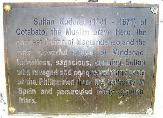
 The statue of Sultan Kudarat (1581-1671) in front of the provincial capitol | Sultan Kudarat. The road then goes through the province of Sultan Kudarat and the towns of Isulan (the provincial capital) and Tacurong City. A tall statue of Sultan Kudarat stands in front of the provincial capitol. |
 |
Glan, Sarangani. About one hour South of Gensan is the town of Glan. The town was thriving in the late XIXth century when many Chinese and Christians moved there from Cotabato and Davao to take advantage of the booming commerce in Sarangani Bay. Finely decorated ancestral houses still stand in Glan.
 Fine decoration of an ancestral house in Glan |  Another one of Glan's ancestral houses |
Gumasa Beach. About 5 km South of Glan lies Gumasa Beach, one of the most beautiful in the country: pure fine white sand sloping gently into the sea, Boracay-style. There are a few resorts on the beach like the White Haven Resort and Rosal Beach Resort. A couple of kilometers South on another beach is the charming Isla Jardin del Mar Resort (picture on the right). The beaches are popular with Mindanaoans and are crowded and noisy during holidays. |  |
 Sunrise on Gumasa Beach | |
 |  |
Balut Island
 Sunrise over eastern Sarangani Province on the way to Balut Island |
 Approach to volcanic Balut Island |
 Flatter Sarangani Island as seen during the return trip |
 The South tip of Mindanao |
| Balut Island. Volcanic and coconut tree-planted Balut Island lies about 10 km South of the southern tip of Mindanao and 170 km from the nearest major Indonesian islands of Talaud and Sangihe. Together with Sarangani Island, it forms the Municipality of Sarangani, in the province of Davao del Sur. The trip by bangka from Glan takes 2.5 hours on a calm sea and is considered safe by the locals (no pirates). The tiny Indonesian island of Miangas located off the tip of Davao Oriental is surprisingly at a higher latitude than Balut and Sarangani Islands. The population is majority B'laan, with some Bisaya-speaking Christians and some Sangil Indonesians who originated from Sangihe Island. Many stories circulate in Glan about the dangers of going to Balut Island, mostly legends propagated by people who have never been there. It is true that the people on the island are rather distant and do not make visitors feel particularly welcome. It is recommended to go there with a local from Balut Island who knows the mayor or barangay officials of the area where you will land. With such official introduction, people become friendly and hospitable. While on the island I inquired about a bird species that was reported in the Philippines only on Balut and Sarangani Islands, the Great-billed Parrot Tanygnathus magalorynchos. Unfortunately all those I interviewed confirmed that the parrot had been extirpated from Balut and Sarangani Islands by habitat loss and poaching. Older men remember that they used to see it often in the forest, but there is no forest left. The bird is still common in some parts of Indonesia. |  A street in Barangay Lipol, Balut Island |
 Our small bangka beached on Balut Island |  Our boatmen, B'laans from Balut Island |  A Sangil Indonesian family near Glan |

Balut Island covered with coconut plantations

Mindanao seen from Balut Island
This comment has been removed by a blog administrator.
ReplyDelete